Spotting methane plumes from space
A new satellite built to track planet-warming methane has been launched into orbit.

In the race to limit global warming, the methane swirling in our atmosphere has emerged as a high-stakes player.
MethaneSAT, which launched in California earlier this month aboard a SpaceX Falcon 9 rocket, is a new satellite designed as an 'eye in the sky' for the planet to keep fugitive gas emissions in check.
MethaneSAT, a brainchild of the nonprofit Environmental Defense Fund (EDF), will circle the planet, scanning for climate pollution that's largely been invisible until now.
Methane is the key ingredient of ‘natural gas’ which can escape unnoticed into the atmosphere, most commonly via leaks in fossil-fuel extraction.
And experts agree that it has a far weightier planet-warming payload than regular carbon, putting it front and centre for regulators and environmental advocates seeking to limit climate change.
"A 75% cut in methane emissions from fossil fuels by 2030 is imperative to stop the planet from warming to a dangerous level."
According to the International Energy Agency (IEA), methane is responsible for around 30% of the rise in global temperatures since the industrial revolution.
“A 75% cut in methane emissions from fossil fuels by 2030 is imperative to stop the planet from warming to a dangerous level,” IEA Executive Director Fatih Birol said.
And the IEA says reducing methane leaks from the energy sector is one of the most “readily implementable and cost-effective measures” to achieve this.
MethaneSAT is not the first methane-detecting satellite to reach orbit, but its mission is to fill in gaps in data from existing satellites by tracking the fugitive emissions from entire regions as well as from smaller sources.
Public accountability
This will facilitate the comparison of emissions across major oil and gas basins around the world and will monitor how these change over time.
According to Chief Scientist at EDF and MethaneSAT project lead Dr Steven Hamburg, this will quantify the total methane emissions for larger regions that have, until now, remained hidden.
“Unlike existing satellites, MethaneSAT's high spatial resolution will enable tracking of emissions from both large and small sources, essential for comprehensive monitoring,” Hamburg said.
“2024 marks the start of a new era of radical transparency in greenhouse gas measurement and, with it, accountability, and action to rapidly reduce methane emissions.”
Another unique feature of MethaneSAT, according to the EDT, is that its data will be publicly available to everyone, adding a layer of accountability and transparency.
This would mean companies, investors and government officials could use its data to supplement their own emission tracking efforts.
“2024 marks the start of a new era of radical transparency in greenhouse gas measurement and, with it, accountability, and action to rapidly reduce methane emissions,” Hamberg said.
“We designed MethaneSAT – from its technical specs, its groundbreaking data analytics and processing system, and commitment to public and transparent data access – specifically to catalyse that action.”
Mission partners include Harvard University’s School of Engineering and Applied Sciences, the Smithsonian Astrophysical Observatory, and the New Zealand Space Agency.
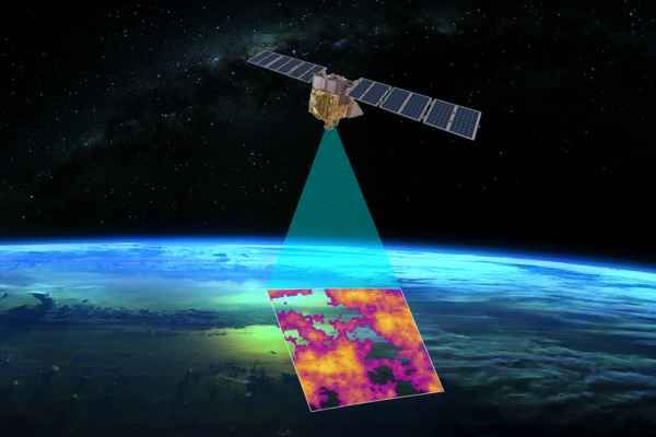
MethaneSAT has the ability to precisely measure methane levels with high spatial resolution over wide areas, allowing it to track methane escaping from oil and gas production, according to Environmental Defense Fund (EDF). MethaneSAT’s wide-camera view is designed to survey large areas – or even whole states or countries, as well as much smaller, diffuse sources that have been found to account for many fugitive emissions. Identifying emission sources for a specific region will allow comparison of emissions across oil and gas basins and track how they change over time at the sub-basin, basin, country or global scales. The cloud-based data platform will be publicly available, providing key insights in a timeframe that allows officials and operators to find and fix problems faster, while allowing stakeholders to compare progress against commitments, and legal obligations.