Sighting carbon sinks from space
A new biomass satellite has captured images that could reshape the measurement of forest carbon stocks.

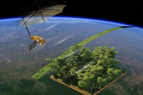
A European Space Agency (ESA) satellite created to map carbon stored in forests has returned its first images.
These early images are already hinting at the potential of the Biomass satellite technology, say mission organisers, as they seek to glimpse beyond the canopy and deep into some of Earth’s most critical carbon sinks.
Forests store large amounts of carbon, but when they are cleared or burnt, the release of carbon is enormous, according to the Climate Council.
The mission of the Biomass satellite is to help address the scientific challenge of accurately measuring how much carbon is stored in Earth’s forests with a view to understanding how that capacity is changing due to deforestation, degradation and climate stress.
The satellite was launched in April as part of ESA’s Earth Explorer program and is the first mission to carry a P-band Synthetic Aperture Radar (SAR), according to the ESA.
With its long-wavelength sensor, it is capable of penetrating dense forest cover to reveal the structure beneath, including tree trunks and branches that store most of a forest’s carbon.
"We’re very pleased to report that everything is functioning smoothly and its first images are nothing short of spectacular – and they’re only a mere glimpse of what is still to come."
“Biomass is equipped with novel space technology,” ESA’s Biomass Project Manager Michael Fehringer said. “We’re very pleased to report that everything is functioning smoothly and its first images are nothing short of spectacular – and they’re only a mere glimpse of what is still to come.”
The ESA says the first image released from the Biomass satellite covers part of Bolivia, which ranks among the global leaders in primary forest loss, much of it linked to agricultural expansion.
Other images from the satellite have captured the Amazon Basin, Gabon, Indonesia, Chad and Antarctica – each highlighting the satellite’s ability to reveal forest structure, wetland terrain, desert subsurfaces and glacial features often hidden from view by other sensors.
The ESA says these first images are still undergoing calibration and are not yet suitable for carbon quantification, but early signs show the mission is on track.
“We fully expect that this new mission will provide a groundbreaking leap in our ability to understand Earth's forests,” ESA’s Earth Observation Director Simonetta Cheli said.
Methane mission ends
As the Biomass Satellite sends its first images, another research satellite has prematurely reached the end of its journey. Advanced methane-monitoring satellite MethaneSAT, stopped transmitting data on June 20 and is unlikely to be recoverable, according to a statement released by the mission team.
Launched in March 2024, MethaneSAT had spent more than a year mapping methane emissions from oil and gas operations globally. Its data revealed both super emitters and smaller, previously undetectable sources, helping to quantify methane’s role in the climate crisis.
The mission, led by Environmental Defense Fund and MethaneSAT, aimed to convert space-based data into actionable insights for regulators and industry. “We have gained critical insight about the distribution and volume of methane,” the team said.
The EDF says an investigation into the satellite’s power loss is underway, and meanwhile, it will continue processing existing data retrieved from the satellite.
Tracking carbon emissions
Climate TRACE, a global not-for-profit coalition of over 100 universities, scientists and AI experts, has released its latest figures revealing a year-on-year rise in global greenhouse gas emissions in April.
The coalition was co-founded by climate campaigner Al Gore and aims to improve the visibility of carbon dioxide and other pollutants in the atmosphere with more accurate and independent real-time data.
Preliminary data from earlier in the year indicated small year-on-year declines in greenhouse gas emissions throughout January, February and March. Its most recent figures, however, indicate that an estimated 5.16 billion tonnes of C02 were released globally in April 2025 – 0.71% higher than in April last year.
The data also indicates that global methane emissions for April rose slightly to 31.94 million tonnes, which was 0.01% higher than the same period last year.
The Biomass satellite mission uses P-band Synthetic Aperture Radar (SAR) to penetrate forest canopies and map structural features down to the forest floor. Unlike optical sensors – which capture only surface imagery – the radar system measures woody biomass (trunks, branches and stems), which act as a proxy for carbon storage. Using the radar instrument’s different polarisation channels, a range of colours can reveal different characteristics of the landscape. Researchers say their use of a unique sampling technique means they can combine multiple observations of the same area to reveal forest height and biomass.